
My, you Planetarians are the kindest creatures! Thankyou so much for the encouraging comments you've left on my last two posts here and here. I can't thank you enough for the *spirit boost* you're giving me. I'll reply to your comments soon - I'm just a little tired now after another huge week of phonecalls, emails, interviews, arrangements, appointments and a reassessment of where we're going. In the interim, I've written this post about something which makes my heart sing - just the mood shift I need right now.
This is a post I've wanted to write for eons. It's about things which make my heart sing, evoke memories, cause curiosity and chart our history.
This is a post I've wanted to write for eons. It's about things which make my heart sing, evoke memories, cause curiosity and chart our history.
 |
| Source |
And I'm mad for them!
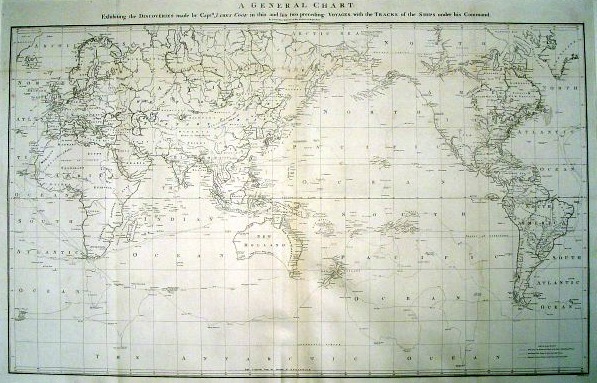
Growing up with maps
Since my early childhood, I've been fascinated by these little complexities, the way in which we've made our marks on the world over the centuries. Kingdoms of the ages have both risen and fallen spectacularly over them. Countless wars have been waged and innumerable lives lost. Families have been wrenched apart, and just as remarkably reunited, by them.
 |
| Source |
I marvelled at the vastness of the world's oceans, the depths of its trenches and the heights of its mountains.
Living on an island myself, I was fascinated by the other tiny islands scattered at the bottom of the Southern Hemisphere, especially at the various European countries which laid claim to them.
It hung on my wall for 23 years, the pink slowly fading with the sunlight and the edges fraying a little. If only I'd held onto it before throwing it away when Mr PB and I started our married life - now vintage ones cost a fortune!
The influence of my land surveyor Dad
 |
| Source |
Dad was Tasmania's very proud 'Registered Surveyor No143' and keenly aware of the rich cultural heritage of his predecessors. These early British colonials had trekked into the vast unknown expanses of Tasmania's wilderness, absolutely oblivious to what lay ahead of them but nevertheless doggedly determined to take measurements and make their marks on the land.
The local Aborigines must have been absolutely flummoxed to see those strange white men, lugging their heaven wooden theodolites through the virgin bush, holding up long measuring poles and writing down numbers. Whatever were they doing?

Studying history at school
Studying 20th Century History at school was even more fascinating as I discovered how the struggles to retain or alter such lines had resulted in so many bitter and bloody wars throughout the world. I was particularly intrigued by the shifting of Poland's borders over centuries, waxing and waning as powerful men toyed with them.
My experiences as an Exchange Student
 |
| Source |
 |
| Henri Cartier-Bresson, The Berlin Wall, 1962 |
I was fascinated by the increasing tension in East Berlin, notably made plain by the moving of the barricades around the Brandenburg Gate. Between my trips, they were pushed further away from the Gate to increase the gap to the border of the Berlin Wall where the Communist East met the Capitalist West.
 |
| Source |
So, my friends, does that give you an *inkling* as to why I'm a committed cartophile?! I've really only touched the surface of my passion here. I'd love to know if any of you share it. I'd like to start a little series of 'Mad about maps' posts - are you up for it? Do tell!